Taconic Mountains Hiking Guide | Alander Mountain Trail via South Taconic Trail

Distance: 4.4 Miles
Elevation Gain: 1,528 Feet
Location: Copake, NY
After too many hours in traffic trying to get to the Catskills a couple weeks ago, I smarten up and leave Brooklyn during those dreamy dawn hours on a Saturday when time and space move a little too easily. I skip from Manhattan into the Bronx and soon find myself on small state highways snaking through forests, cornfields, and private property signs.
I reach my destination earlier than I’d anticipated and turn back to what I’d been reading about the hike. Alander Mountain is in the Taconic Mountain range within the Appalachian Mountains. The Taconics start at the northeastern end of the Hudson Highlands and run due north along New York’s eastern border through Connecticut, Massachusetts, and Vermont. On just the short stretch of South Taconic Trail on this hike, you cross the Massachusetts border three times. “Timber rattlesnake” is mentioned once, twice… several times.
I walk down the road towards the trail. Grey day with leaves starting to turn. Some fall slowly between branches onto the road. I see the trailhead and make my way into the woods, more aware than usual that mottled colors of fallen leaves probably make great camouflage for snakes. Every scurrying squirrel, every leaf blowing in my periphery, every twig breaking under my boots heightens my awareness.

I reach a fork and start on the Robert Brook Trail to follow the trail counterclockwise. The sign is in a state of suspended consumption. Seems equally curious and sisister, as though the woods are reclaiming the trail.

The forest is all deciduous trees with spindly trunks, branches and leaves reaching for pockets of sunlight leaving the trail shaded. I’m always surprised at how far I can see in woods like these.
Before long, I hear the soft rushing water of Robert Brook off to the right, and the sound stays as a constant companion for a little ways. Sometimes, you can see small waterfalls not too far in the distance. The trail itself stays steep and steady but quite wide. An ATV could probably handle most of this first part.

The Robert Brook Trail ends after about 1 mile, and I take a left onto the South Taconic Trail, which is very leisurely and level for the most part. A good place for thinking quietly and observing the changing foliage. As leaves slip from their stems and drift through the air, it fills me with a kind of nostalgia, and I start to wonder if we’re programmed to feel that way in the fall, if that sweetness is supposed to help us get through the winter months.

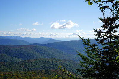
The trail gets tight and steeper near the top, but when the trees open up and reveal the view, it’s all worth it. The Taconic Mountains slope down into this idyllic pastoral landscape in the distance, which only feel familiar to me from paintings.

The other side of the loop feels like a mirror image of the Robert Brook Trail. Steady, steep, and wide with small waterfalls popping up but on the left now.

AllTrails describes this hike as, “Hard,” which I don’t really think it is. I sometimes wonder if some of these “Hard” hikes are rated that way to keep them from becoming too popular. There’s nothing very technical. I’d think this could be fun for trail running, too.


Leave a comment